Four Days in Meghalaya
Trust me, the name of this North-Eastern state is no hyperbole
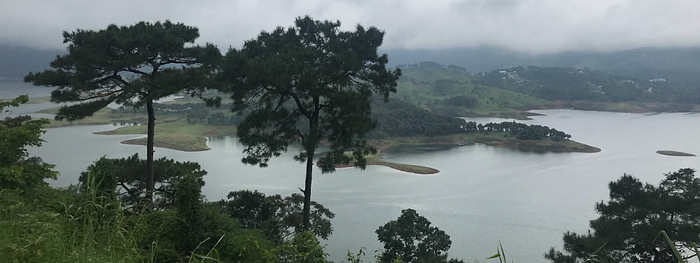
In the third week of October this year, my parents needed a break. They were emerging from a rough month and a half. So my partner flew in and we kidnapped them for a quick trip to Meghalaya. I thought they were being cliché when they named the state “abode of the clouds”. I was wrong. There are hills rolling through the state — specifically, three ranges: Garo, Khasi & Jaintia. These ranges also represent the three primary communities in the state. They aren’t the highest ranges either but there were more clouds than I’ve seen anywhere in the Himalayas. Forget the ranges, there were dense clouds over tea fields in the valley. My dad was so amused re: the clouds just hanging out in our car. Which makes driving around the state serious business. Visibility suddenly drops to 10 meters, and stays that way for entire stretches of time. When the clouds clear though, you are greeted with views like so.

Okay, now let me bring this rambling blog to order.
Day 1
We flew into Shillong airport (you could also fly to Guwahati, it’s cheaper + more flights, but it adds 2 hours travel time because you have to then drive to Meghalaya). This is one of the most picturesque airports I’ve seen. It’s tiny and spotless and is surrounded by hills. We then decided to take a circuitous path to our destination — Sohra (Cherrapunji). And yes, you’re right, Cherrapunji used to be the place with the highest rainfall in India (we’ve all checked that off in some quiz in middle school). Our first stop was the beautiful Umiam Lake. If I had to do it again, I would take a boat ride around because just look at those land structures..

We then stopped for a chaotic lunch at a mess in Shillong and had a proper Khasi thali (well Anurag and I had the vegetarian version so don’t count on us for proper reviews). Lots of radish featured in the dishes in ways that I haven’t eaten radish before. Super punchy, fermented flavors. The rest of Shillong was like any other hillstation. Parents enjoying said Khasi thali below.

We stopped at a few more waterfalls on the way to Sohra, but these had nothing on the ones we saw on the rest of the trip. Our resort (Jiva) was literally at one end of the world. We were on a hill top and woke up to clouds after a fabulous dinner (I mean obviously, we are in a state that knows how to cook pork and cook it well).
Day 2
An important one. It was the day that marked my first hike with my mother.

We hiked down to Nongriat village chasing waterfalls and the famous double —decker root living bridges. My father has hiked a lot. But my mother was the trooper on this hike. This was no dummy hike either. It was the equivalent of climbing ~150 super steep floors. Here’s what you find when you make it to the village and the sacred grove.

Dad and the husband went further up to see Rainbow Falls (adds about 1.5 hours to a ~6 hour hike) while I coached my mother back up the hill.

Post our hike and post — hike customary maggi, we cleaned up to catch sunset at the Nohkalikai Falls at sunset.

We then got super late for dinner because we were trying to track down the best Pork momos in Sohra. This place that does not show up on google maps is called Me-Ai food corner. Ask the locals, it’s next to a church in the marketplace. The best dumpling family thing I’ve eaten in my entire life’s existence.
Day 3
We started by driving out toward Jaintia Hills, but not all the way to the famed crystal clear Dawki river. We didn’t do Dawki since this was post — monsoon and the water would be murky. Instead, we decided to check out this literally off — the beaten path lake. Thanks to a PMGSY rural road, we actually made it to this spot.

Rolling hills, pristine views and not a soul around. What’s not to love. This was Langkawet. From here, we tried going off on a hike on our own to see more root bridges… except we got lost. Trust me when I say, this place is not commercialized. It’s super easy to get lost because no trail marks or guides. But the views keep giving.

If we had more time, we would have visited Kongthong: the village which needs no Adhaar card/unique ID. Everyone who is born here is given a unique tune. This is also called a whistling village because people will whistle or hum your unique tune to call you instead of unmelodiously yelling out your name. How cool is that!
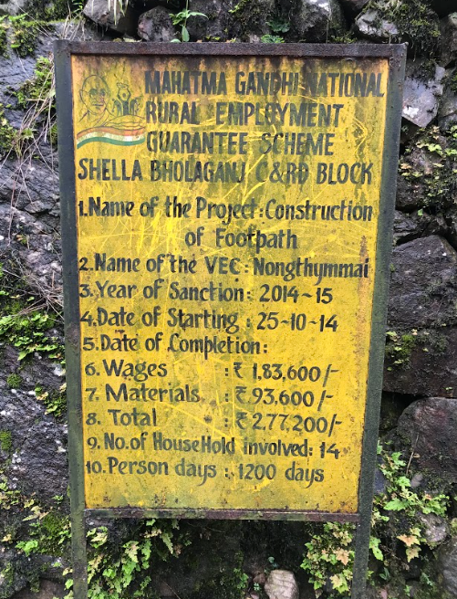
Aside: are we really a policy couple if we didn’t take pictures of every MNREGA project pillar we crossed?

The views on the way back were equally unreal…

Day 4
On our last day, before catching our flight back, we snuck in a trip to a small-ish (by Meghalaya standards) cave system — The Arwah Caves. Though for cavers, there’s plenty of much larger cave systems for you to explore.

Miscellaneous
We also saw the Bangladesh delta from Cherrapunji. This was a non-trivial moment for us. Both my parents belong to Bangladesh refugee families. So it was full circle — esque for us.
Also, two — thirds of the Meghalayan population is Christian. Literacy rates are high. Children walking miles to school are an artefact of the landscape no matter how remote your destination is. It was also the first Indian state to go open defecation free (!)
Meghalaya is also part of the “Zomia” region courtesy James Scott. In a text I read by Scott, way back in undergrad, I remember him describing the hills as the fingers of a hand (palm facing down). The imagery never left me and was spot on.

Meghalaya is a precious state. We barely scratched the surface of everything it has to offer. The next time I visit, I want to go see the wildlife in the Garo hills. But if caving, mountain biking, canyoning is your thing, then too, the state has a ton to offer. Or if looking at beauty that makes you want to cry is your thing. Then too, the state has a lot to offer.
Anyhow, thank you for reading my rambling travelogue till the very end.
